


Chatellier Lécoussel court

coglais
User
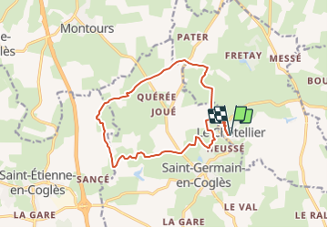

Length
13.7 km

Max alt
186 m

Uphill gradient
232 m
Km-Effort
16.8 km

Min alt
117 m

Downhill gradient
232 m
Boucle
Yes
Creation date :
2017-02-01 00:00:00.0
Updated on :
2017-02-01 00:00:00.0
2h30
Difficulty : Medium

FREE GPS app for hiking
 SityTrail
IGN / Geographical institutes
SityTrail Plus
The world is yours!
About
Trail Nordic walking of 13.7 km to be discovered at Brittany, Ille-et-Vilaine, Le Châtellier. This trail is proposed by coglais.
Description
par Lécoussel
Positioning
Country:
France
Region :
Brittany
Department/Province :
Ille-et-Vilaine
Municipality :
Le Châtellier
Location:
Unknown
Start:(Dec)
Start:(UTM)
629216 ; 5363896 (30U) N.
Comments